CARTSCAN
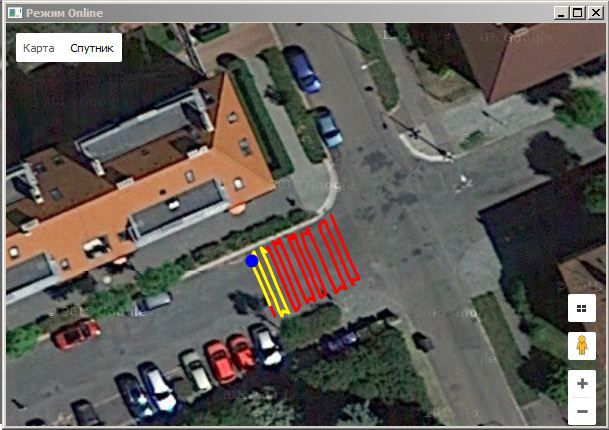
This GPR system is designed to determine the depth and position of utilities such as pipes, cables, reservoirs and drainage systems in a variety of soils at different depths. The"CartScan" software allows its user to see all information displayed in Google Earth.
CartScan - Locate and map underground utilities
This GPR system is designed to locate the depth and position of utilities such as pipes, cables, reservoirs and drainage systems in a variety of soils at different depths. The"CartScan" software allows its user to display all information on Google Earth.
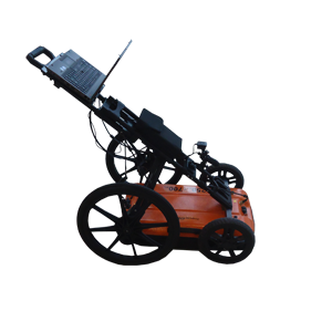
The kit consist of:
•Dual frequency antenna;
•Removable wheels with two integrated odometers;
•GPS-receiver;
•Lightweight rugged trolley;
•Power supply unit.

Features
•Dual-frequency antenna (250 and 700 MHz) for deep and surface surveys in a single scan;
•Two odometers embedded in the wheels for more accurate marking;
•Real-time data collection;
•Enhanced 3D capabilities;
•Automatic GPS integration;
•Google Earth Integration.
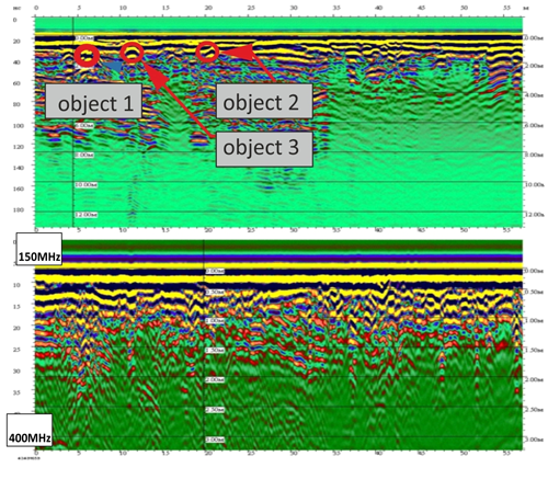
CartScan is a turnkey GPR solution for detection of buried utilities. The systems consists of dual-frequency antenna (250 and 700 MHz), GPS-receiver, and two odometers built into the wheels of trolley. By using data collected from the odometers and GPS-receiver simultaneously, the user can locate and mark utilities accurately and quickly.
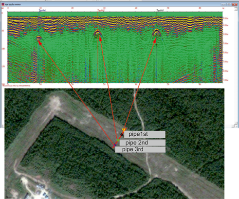
An antenna with dual frequencies of 250 and 700 MHz provides GPR data at depths of 5 and 8 meters simultaneously or separately. The special software "CartScan" allows the user to visualize 3D data, and see all communicated information on Google Earth.
| Central frequency | 250 and 700 MHz |
| Resolution | 0.25 and 0.1 m |
| 250 MHz | 0.25 |
| 700 MHz | 0.05 |
| Power consumption | 8 W |
| Weight | |
| Antenna | 9 kg |
| Trolley | 5 kg |
| Size | 74x46x19 cm |
| Antenna | |
| Trolley | |
| Temperature | -30 +50°C |
| Environmental | |
| GPS |
Possibilities of the Cartscan software package
- Designed for GPR surveys using several antenna units
- Compatible with all types of motion sensors and GPS-Glonass receiver
- Displaying the movement trajectory on the map and plan
- Option of scanning in dual-channel mode, viewing each channel separately, viewing a combined radargram
- Editing the trajectory obtained during scanning
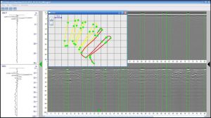
- Building a three-dimensional model based on the received data
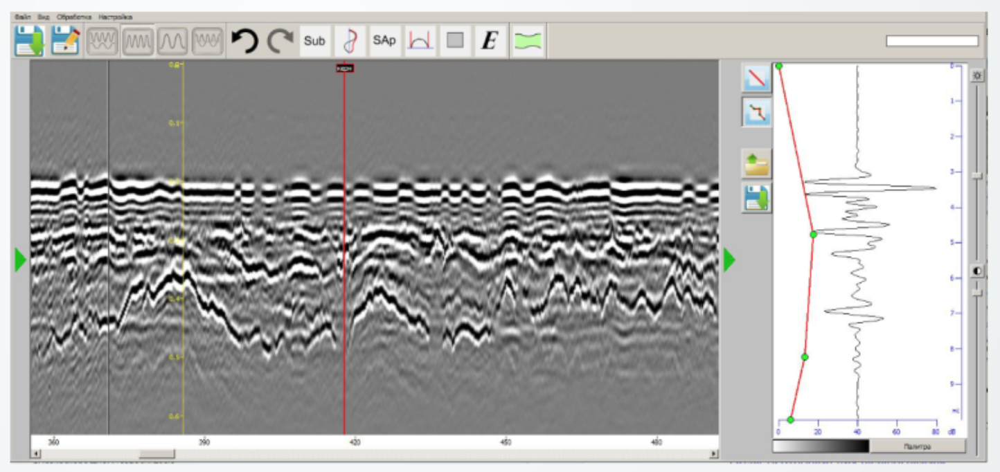
- Possibility of processing received GPR profiles
- Algorithm for automated layer picking and detection of high-energy zones
- Attribution analysis processing module
- Scanning module version for Android-based mobile devices (when using OKO-3)
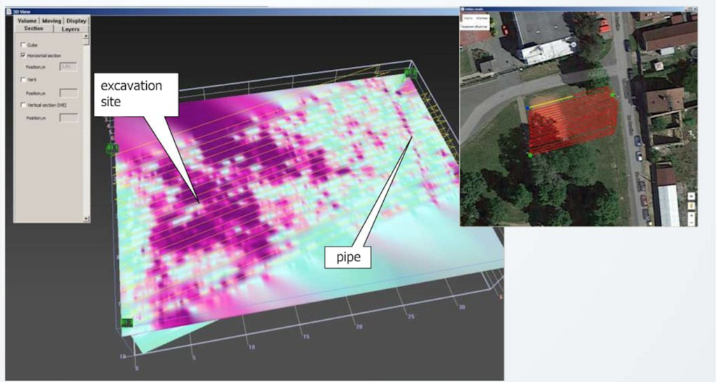
Special software allows the user to visualize 3D data and see information about utilities on Google Earth. CartScan Software is WindowsTM based.
Features
•Scanning with data saved to GPR format file
•Displays current position on map
•Calibration of two wheel trolley geometry parameter
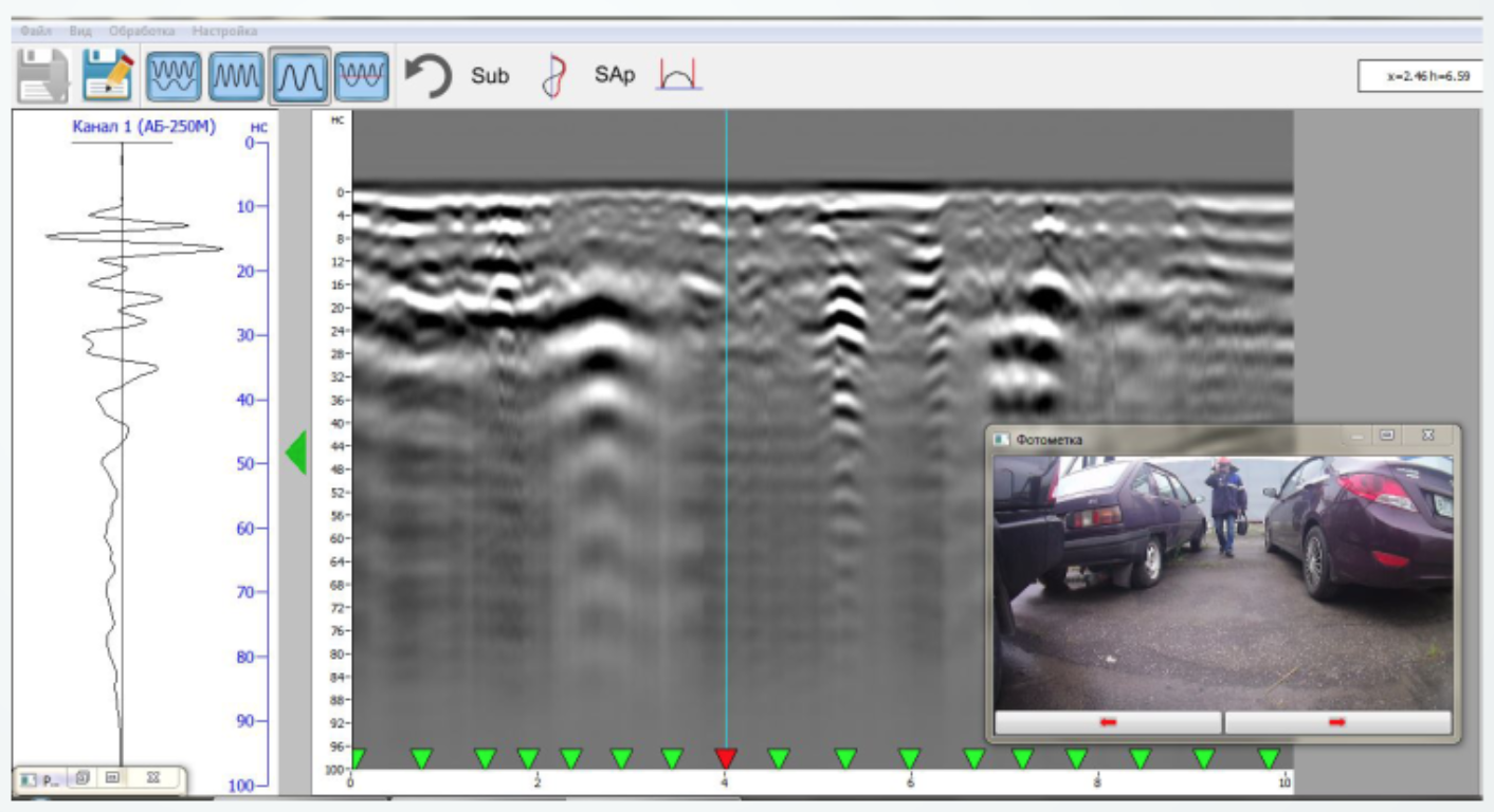
•Storage sound marks
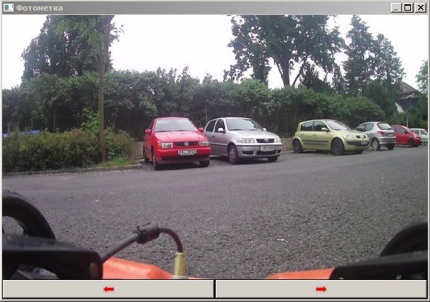
•Storage photo marks
•Viewing collected files in two channel mode, viewing each channel separately
•Viewing movement path on map during collected files preview
•Viewing photo marks while looking through collected files
•Creating 3D profile
•Data processing during collected files preview

The software set consists:
•Scanning;
•Options;
•Data processing;
•Loading map;
•Track editor.


Scanning (active when the antenna and geo location unit (GLU) are connected – work begins in scan mode). If operation without GLU is ordered in settings, the button will be active if only single antenna is available.
Options – software setting parameters change.
Data processing – operation with data file, obtained during scanning mode operation.
Track editor – tracks (move trajectory) shape and location editing obtained during scanning, and which will be included in the file.
Exit – Shutdown work with the software package.
Loading map (active only when Internet connection is available) – download maps to buffer allows for use without Internet connection
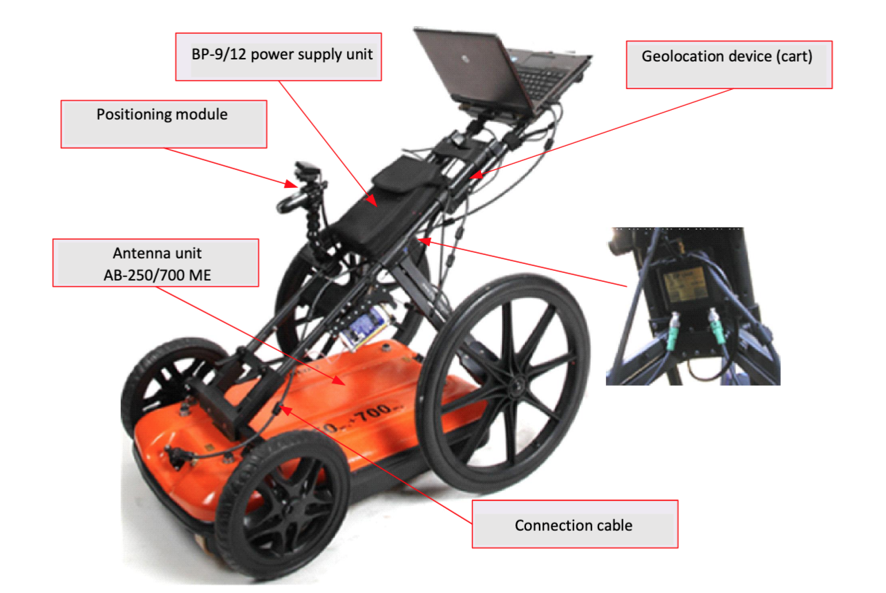
Composition of the GeoСart 2D complex:
1. AB-250/700ME Antenna unit
2. GD-2 Geolocation block
3. Positioning module
4. BP-9/12 power supply unit
5. ZU-9M charger
6. Geolocation device (cart)
7. GeoScan-32 software professional version
8. CartScan software
9. Connection cable
10. Transport laying
11. Packaging
•Dual-frequency antenna (250 and 700 MHz) for deep and surface surveys in a single scan;
•Two odometers embedded in the wheels for more accurate marking;
•Real-time data collection;
•Enhanced 3D capabilities;
•Automatic GPS integration;
•Google Earth Integration.
The special software allows the user to visualize 3D data and view utility network information in Google Earth. The CartScan Software is WindowsTM based.
Features
- Scanning with data saved to GPR format file
- Displaying the current position on map
- Calibration of the two-wheel trolley geometry parameter
- Storage sound marks
- Storage photo marks
- Viewing collected files in two channel mode, viewing each channel separately
- Viewing driving path on the map during the collected files preview
- Viewing photo marks while looking through collected files
- Creating a 3D profile
- Data processing during the collected files preview

The software features include:
- Scanning;
- Options;
- Data processing;
- Map loading;
- Track editor.
Scanning (active when the antenna and geo location unit (GLU) are connected – work begins in scan mode). If operation without GLU is selected in the settings, the button will be active when only the antenna is available.
Options – software setting parameters change.
Data processing – operation with the data file, obtained when working in the scanning mode.
Track editor – editing shape and location of the tracks (movement trajectory) obtained by scanning, and which will be included in the file.
Exit – shutting down work with the software package.
Loading map (active only when an Internet connection is available) – download maps to the clipboard allows using without an Internet connection.