What is GPR?
Ground penetrating radar, or GPR, is the most modern and rapidly developing geophysical method. The possibilities of its application are being investigated, the number of tasks that it is capable of solving is increasing, and the equipment is being improved and modified. Today, GPR is used to investigate depths from the first centimeters (e.g. when monitoring the laying of runway surfaces) to hundreds of meters in the glaciers of Spitsbergen and the Caucasus. In accordance with the modern requirements of science and production, equipment for solving specific problems with pre-installed programs for automatic processing of GPR data is serially produced. The same applies to research kits for a wide range of applications, which are used by scientists for field and laboratory research. The simplicity and speed in carrying out field work using the ground penetrating radar method combined with the light weight of the equipment set make it possible to carry out GPR surveys on the ground, from the air, under water, and in space.
And a GPR system is a device for non-destructive research of various environments and objects, operating on electromagnetic waves. In order for the GPR signal, an electromagnetic wave, to penetrate inside, the research environment should not conduct electric current. And such environments and objects are the absolute majority in the world. These are soils, grounds, and rocks. These are fresh water, ice, and frozen rocks. These are car roads and railways (excluding rails themselves), foundation slabs, house walls, bridges and any concrete, stone, and wooden structures, etc.
GPR does not work in salt water and soils saturated with it, in clays, loams, and clay rocks (these are soils that weakly conduct electric current), and if an iron sheet lies on the surface of the study area.
At the same time, GPR systems are absolutely safe for humans and all living things.
How Does GPR Work?
In most cases, the work by the GPR method is carried out as follows: the GPR antenna, located on the surface of the studied object, emits an electromagnetic signal which in turn penetrates the environment. A part of the signal energy is reflected, and the other part continues to penetrate and is reflected already from boundaries and objects that are located deeper or further along the path of the electromagnetic wave. All the reflected energy returns back to the surface, where the signal is received by the same or similar antenna (receiver) and recorded. Then the GPR moves forward along the surface “cut line”, the signal is emitted, reflected, and recorded.
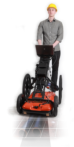
The weight of modern GPR devices is so small that they can be easily carried by one person. In addition, they work so fast that they manage to “see through” the environment, being in a car that moves at the speed of the flow.
What Can GPR Detect?
From what boundaries and objects is the GPR signal reflected? From any boundaries at which there has been a change in electromagnetic properties. These are any boundaries associated with changes in moisture, voidness, and the composition of a solid matrix: the boundary between wet and dry soils, between soils and rocks of various compositions and origins, between asphalt and concrete; the bottom of reservoirs, the depth of freezing and the bottom of ice, a hollow in a tree and even different layers in its trunk – electromagnetic waves will be reflected from all these boundaries. There will also be reflections from the upper surface of the clays, from standing salt water in fresh water (halocline) and even from standing water of a different temperature in the reservoir (thermocline).
Objects that can be found using GPR are all kinds of pipes, collectors and cables, boulders of rocks in loose (for example, in sand), various archaeological objects (statues, foundations, burials), and, of course, rods reinforcement in concrete slabs.
But note that it is impossible to find coins or shards from earthen vessels – they are too small.
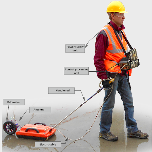
GPR Survey Equipment
Ground penetrating radar equipment includes the following:

– Laptop, tablet, smartphone, or any other device to control the GPR. Ordinary mass-produced devices with a special pre-installed application will do. The device can also record GPR data.
– GPR unit – “brains” with electronics, which will control the process of the GPR survey.
– Power source for the GPR(battery). Some GPR systems come with a built-in battery.
– A device for measuring distance and geodetic referencing of data on the ground – an odometer or a measuring wheel, which can also be built-in or attached separately, depending on the tasks of the study.
A GPS or GLONASS receiver is not included in the kit but can be connected. The “OKO” GPR can automatically take its readings and write to its data files.
– Wires to connect all parts together. Wi-Fi technologies are used in the “OKO” GPR, which means that they require fewer wires than the previous generation GRPs.
– Antennas (the most important part of a GPR). Usually, these are two identical antennas that perform the functions of a source and a receiver, structurally located in the same body.
Antenna units come in a variety of sizes and configurations. The larger the antenna, the deeper the signal penetrates, and the larger the minimum object size or layer thickness that can be “seen” with this antenna.
To understand which antenna suits you best, focus on the central frequency of its signal in the air (always indicated in the antenna name): in order to “see” something at a depth of the first centimeters, antennas of 1 GHz and higher are needed. The frequency of the deepest antennas is about 50 MHz, and their signal penetrates to depths of tens of meters. The range of GPR antennas is wide and you can always choose the right antenna for the required depth.
Equipment Types Based on GPR Technologies
Currently, there are two types of GPR systems. The first type is multipurpose GPR for solving various tasks, from studying a geological section to measuring electromagnetic properties in a laboratory. Such devices are mainly used by scientists: geophysicists, geologists, geographers. To solve different problems, different sets of equipment are assembled and different antenna units are used, connected to one control unit. The “OKO-3” GPR works with 50 MHz, 90 MHz, 100 MHz, 250 MHz, 400 MHz, 900 MHz, 1200 MHz, 1700 MHz, 2000MHz and 2500 MHz antenna units.
The other type of GPR device is a special GPR for solving specific tasks. This is an already assembled, structurally rigidly connected set, often with special software for semi-automatic or automatic processing of GPR data. For example, the LD-400 and LD-1200 leak detectors automatically determine the thickness of ice from 20 cm to 8 m. The multichannel GPR complex “OKO” for railways can be installed on a train or move on rails independently. The CS-1700 3D GPR builds a three-dimensional image of the internal structure of the concrete environment. With the help of the radar-detector RD-400, you can search for survivors under rubble or behind a wall in a room.
GPR Penetration Depth & Application
The table below will help you understand which antenna to choose:
| Concrete Roads Runways Engineering structures | 1700 MHz | 0-0,5 m |
| Roads Runways Engineering structures Soil Archeology Ice thickness | 900 MHz | 0 – 1.5 m |
| Soil Archeology Geological tasks Searching for the bottom of reservoirs | 400 MHz | 0 – 5 m |
| Soil Archeology Geological tasks Searching for the bottom of reservoirs | 250 MHz | 0 – 8 m |
| Geological profiling Study of bottom sediments of deep reservoirs | 100 MHz | 0 – 14 m |
| Geological profiling Study of bottom sediments of deep reservoirs | 50 MHz | 0 – 30 m |
GPR Data Processing
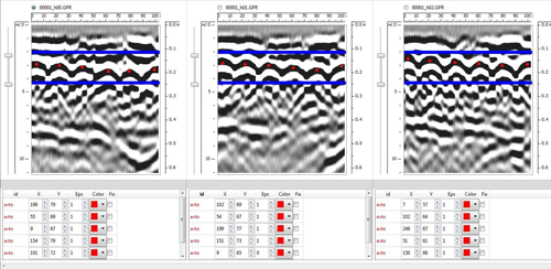
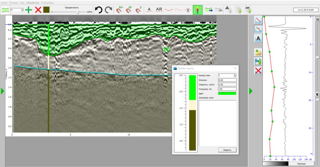
GPR data is collected by profiles and then transmitted for digital processing. Digital processing is needed in order to remove noise in the data, amplify reflections coming from deep boundaries, calculate depth, etc. Processing is carried out in the same GeoScan32 software package, which was used to control the GPR during the survey.
The CartScan software package contains an interpretation block in which you can select the necessary boundaries and objects, create and export a model of the environment in a graphical format. CartScan software can be used for the analysis and interpretation of areal GPR survey data. It helps to bind data to a map and display selected objects (e.g. utilities or anomalous areas) on a digital image of the terrain. This program automatically selects areas of increased reflection amplitude, which is one of the signs of high humidity zones
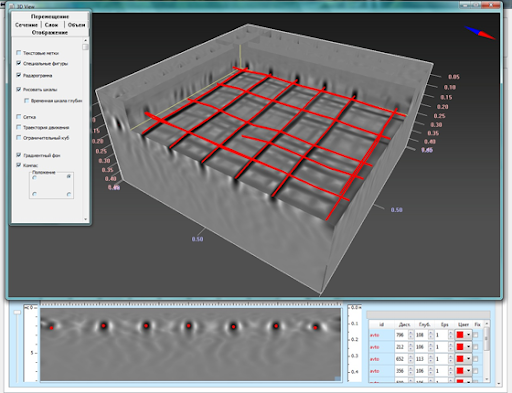
If the data is obtained from a grid of parallel profiles located on the same area, it is possible to build a three-dimensional image of the environment and maps and then analyze GPR data not in a section, but in a plan.
Also, GEOTECH has implemented software for the analysis of ground penetrating radar data obtained on the railroads and in the study of concrete slabs.
Special-purpose GPR systems have pre-installed software for automatic processing and additional data processing is not required.
Application of GPR Equipment
Archeology
GPR is widely used in archeology in different countries. To search for foundations of temples (Italy), burials under the floor (Petra, Jordan), ancient statues (Egypt), and even determining the age of mounds (Japan).
The use of this method of non-destructive exploration can significantly reduce the area of excavation and reduce labor costs.
Ground penetrating radar works for archaeological purposes are carried out along a network of parallel profiles. And then, in special software, three-dimensional models are built for layer-by-layer analysis of soils and grounds. This allows you to highlight areas of interest for further excavation, to determine the depth intervals.
Often, GPR is used for historical and cultural expertise before construction in order to determine if there are any archaeological monuments or burials on the territory and whether construction can begin.
Road Inspection
A road network is the most important part of a modern country. Where there are roads, there is civilization. It is extremely important not to stop the traffic flow on the highway, even for the GPR inspection of the road pavement.
For these purposes, GEOTECH has developed an automobile version of the “OKO-3” GPR, which can be installed on a car and survey at the flow rate. Installation of various antenna units allows you to solve various problems: from determining the number of asphalt layers and their thickness to determining the structure of the geological section under the road.
Further, in a semi-automatic mode, using the Geoscan software, structural layers can be detected, and the objects and areas of high humidity selected in the CartScan software will be plotted on the road map.
Railway Inspection
The destruction of the railways can lead to accidents, train stops, and significant economic losses.
To prevent the destruction of the embankment and timely determine its condition, search for subsidence, leaks, and more, it is necessary to carry out monitoring.
For these purposes, there is a multichannel railway antenna complex “OKO-3”, which allows receiving data simultaneously on three profiles: along the center of the embankment and along the edges. The complex can be installed on a train or move autonomously.
The latest version of the software for processing data obtained on the railways implements the possibility of automatic processing and interpretation of radarograms, analysis of the thickness of structural layers, moisture, and slope. Automatic generation of reports is available.
Concrete Scanning
GPR allows solving the whole range of problems of non-destructive testing of concrete structures: searching for cracks in walls and concrete slabs, building three-dimensional images of reinforcement, determining the number of layers and their thickness, searching for air cavities, utilities in walls, and supporting structures.
A search for subsidence and areas of high humidity under concrete slabs of the foundation, road, and runway can be carried out.
For these purposes, there is a whole line of special antenna units for the “OKO-3” GPR, as well as specialized GPR devices for concrete scanning, with the help of which non-destructive testing can be carried out in real time.
In the case of concrete structures located under water (dams, sluices), a unique development is used – the “OKO-3” ground penetrating radar with an underwater antenna unit, designed to carry out work with the immersion of the device to a depth of up to 10 meters.
Oil & Gas Field
GPR is widely used to solve problems associated with existing oil fields or with the construction of new ones. The tasks of monitoring the safety of pipelines, measuring the thickness of ice for winter crossings of heavy equipment, searching for the roof of bedrock for laying explosives for “big seismic exploration”, etc. are being solved.To search for and determine the position of pipelines at the bottom of reservoirs, you can use the standard search kit “OKO-3” with butterfly-type antennas in a plastic or rubber boat, or TritonM antennas and an underwater antenna unit.
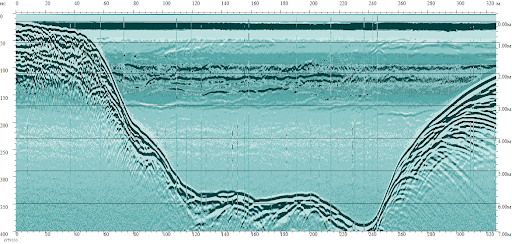
Dam Inspection
The task of a complete survey of dams to determine their condition and calculate reconstruction measures is best solved using a set of geophysical methods: seismic exploration, electrical prospecting and ground penetrating radar.
GPR profiles are laid along the upper edge of the dam and at the foot. GPR is used to search for leaks, which are distinguished by areas of increased amplitude and lower frequency, and to determine the position of the boundaries of the structural layers of the dam.
The most commonly used equipment for these purposes is a GPR kit with a 400 MHz antenna unit. This antenna is lightweight, convenient for field work, and the signal penetrates to a depth of 5 m.
Utility Mapping
Utility mapping communications is a common task that arises in a dense urban environment. In this case, it is required to find as cables that lie at shallow depths, as pipelines and collectors located at a depth of more than 2 m.
In addition, it is often necessary to solve the problem of finding leaks and voids under the asphalt-concrete pavement.
In this case, antennas with two different frequencies should be used: a high-frequency antenna unit with a depth of up to 1 m and a resolution of up to 1 cm, and a lower frequency antenna unit, for a greater depth of signal penetration.
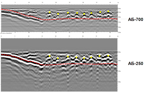
For these purposes, a two-frequency GPR complex “GeoCart 2D” has been developed, which makes it possible to simultaneously receive data from an antenna of 700 MHz and 250 MHz. The complex is installed on a convenient trolley and is equipped with a number of technical means that greatly facilitate and accelerate the conduct of areal surveys on the ground: a topographic reference device with a satellite positioning system, with which the survey can be carried out along an arbitrary trajectory, a video recorder for linking detected objects in the ground to real objects on the surface (buildings, trees, hatches, etc.). The CartScan software package used in the GPR complex quickly visualizes the data and a reliable three-dimensional model. Information about the found communications is displayed on the digital Google Earth snapshot.
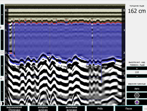
Ice Thickness
Ice thickness is a factor on which the safety of ice crossings directly depends. The electrophysical properties of ice and water are significantly different, which makes it possible to successfully use GPR to search for the bottom of the ice and determine its thickness.
Depending on the availability of a priori information, from the point of view of safety and optimization of costs for field work, the LD-400 Ice meter installed on a car, the LD-1200 Ice meter, which is carried by a person, or an LD-400 modification fixed on a UAV can be used.
GPR data is processed automatically and an operator receives visual information about the ice thickness, standard load, cracks, and irregularities within the array in real time.
Geology, Soil Science, Geography
Ground penetrating radar allows solving all problems related to the dissection of the section and the determination of the properties of various layers. The method can be used for the following geological, engineering-geological and hydrogeological tasks:
– mapping of geological structures – the restoration of the geometry of relatively long boundaries, the surface of bedrocks under loose sediments, the level of groundwater, the boundaries between layers with varying degrees of water saturation, the search for sediments of building materials;
– determination of the properties of various sediments by the speed of electromagnetic waves propagation, based on the connection of these properties with the dielectric constant of rocks;
– determination of the thickness of the water layer and mapping of bottom sediments;
– determination of the thickness of the seasonal freezing zone, delineation of permafrost areas, taliks;
Often, geological, geographical and soil science problems are non-trivial and require preliminary planning of the methodology and careful selection of equipment. At the same time, the line of “OKO” GRPs and antenna units allow solving problems of any complexity, detail and resolution. The depth depends primarily on the properties of the section and can reach hundreds of meters in glaciers or tens of meters in frozen rocks.
Permafrost
Differences in the electrical properties of ice / water / air / soil make it possible to successfully use GPR when studying the first 30 meters of the cryolithozone section, and in some cases even deeper when the frequency is lowered. The boundary of the phase transition of water will be very contrasting for high-frequency electromagnetic waves, the insulating properties of ice provide small losses, and, therefore, a large penetration depth of the electromagnetic signal. For example, in the article [Arcone, S.A.and Delaney, A.J. Stratigraphic profiling with ground penetrating radar in permafrost: possible analogs for Mars, Journal of Geophysical Research, Vol. 107, No. E11, 2002], the data obtained with a 50 MHz antenna are presented, on which there is an in-phase axis corresponding to a depth of 80 m.
In the field of permafrost development, the following tasks can be successfully solved using GPR:
1.2. Mapping of the roof and bottom of the permafrost.
1.3. Determination of the depth of seasonal thawing or freezing.
1.4. Search for taliks, monitoring the development of taliks in time.
1.5. Search for leaks under buildings and roads.
2. Determination of the physical properties of the layers:
2.1. Lithological dissection of the section.
2.2. Determination of ice content or search for areas of “increased ice content”, search for wedge ice.
2.4. Determination of the moisture content of the thawed layer and the amount of non-frozen water.
etc.
All these problems are being successfully solved. A number of publications are devoted to each of them in world scientific literature.
Benefits of GPR Usage
Ground-penetrating radar has three main advantages over other indirect (and direct too) geophysical exploration methods:
– This is a completely non-contact method that does not require any special surface conditions or immersion of the sensors in the objects under study.
– This method is the most labor-intensive and simple from the point of view of organizing and conducting field work.
– The cost of a GPR profiling unit (e.g. a running meter) is many times lower than the cost of research by other methods.